Baratang Island:
Limestone Caves, Mangroves, and a Different Andaman
Baratang Island: Exploring the Hidden Geological and Mangrove Heart of the Andamans
Beyond the postcard-perfect beaches and turquoise lagoons that define popular perceptions of the Andaman Islands lies Baratang Island—an entirely different expression of the archipelago’s natural character. Baratang is not about leisure in the conventional sense; it is about discovery, transition, and ecological depth. Here, dense mangrove creeks replace open beaches, limestone caves replace coral reefs, and forest corridors replace coastal promenades. This island introduces travelers to an Andaman that is quieter, more complex, and profoundly shaped by geology and estuarine systems.
For explorers who value landscape diversity and scientific curiosity, Baratang Island represents a crucial missing link in understanding the Andamans as a whole. It connects coastal marine systems with inland forests, subterranean geology with surface hydrology, and human access with carefully regulated conservation. This comprehensive guide presents Baratang Island as a destination of learning, movement, and controlled exploration.
Geographical Location and Strategic Importance
Baratang Island is located roughly 100 kilometers north of Port Blair, positioned between South and Middle Andaman. Unlike most island destinations in the archipelago, Baratang is connected by road, making the journey itself an integral part of the experience. The route passes through protected tropical forests and designated tribal reserve zones, emphasizing the island’s ecological sensitivity and administrative importance.
The island’s geography is dominated by mangrove-lined creeks, limestone formations, and dense evergreen forests. It does not present a singular landscape but rather a layered environment where freshwater, brackish water, and marine systems intersect.
Why Baratang Is Considered a “Different Andaman”
Baratang does not offer conventional beach tourism. Instead, it introduces travelers to geomorphology, estuarine ecology, and forest-driven island dynamics. This distinction makes Baratang an educational and exploratory destination rather than a recreational one.
The Journey to Baratang: Travel as an Experience
Reaching Baratang Island is not merely a transfer; it is a carefully regulated passage through protected landscapes.
Road Journey Through the Andaman Trunk Road
The journey begins early from Port Blair along the Andaman Trunk Road. Convoy systems are often used to regulate movement through forested and tribal reserve areas. This structured travel highlights the balance between accessibility and preservation.
Crossing Creeks and Ferries
Short ferry crossings connect road segments, offering views of calm waters bordered by dense mangrove forests. These transitions mark the gradual shift from mainland-style travel to island-specific environments.
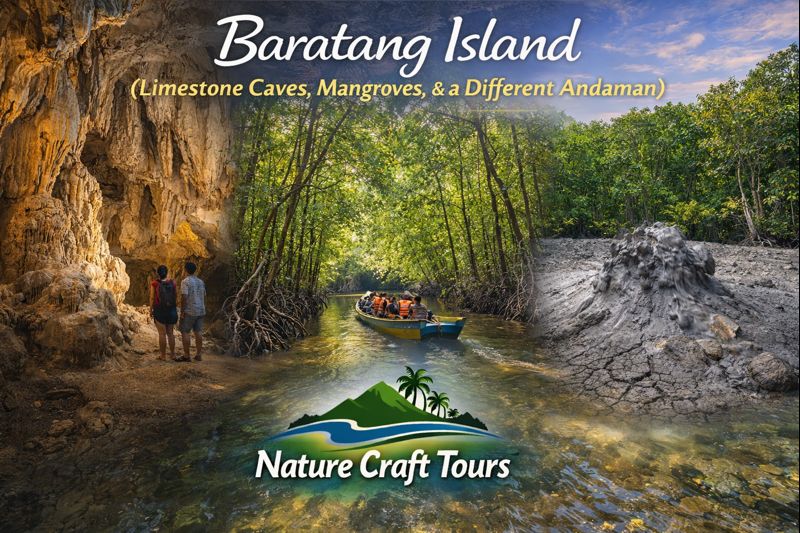
Mangrove Ecosystems: The Living Corridors of Baratang
One of Baratang Island’s defining features is its extensive mangrove network. Boat journeys through narrow creeks reveal towering mangrove roots, arching branches, and shaded waterways that feel almost tunnel-like.
Mangroves here play a critical ecological role—stabilizing shorelines, filtering sediments, and serving as nurseries for aquatic species. The calm, brackish waters support fish, crustaceans, and mollusks that form the base of the local food web.
Mangrove Exploration as an Interpretive Experience
Unlike open-water boating, mangrove navigation is slow and deliberate. The experience emphasizes observation over movement, similar in philosophy to river-based journeys undertaken during a Sundarban Tour, where the ecosystem reveals itself gradually.
Limestone Caves: Subterranean Narratives of Time
The limestone caves of Baratang are among the most scientifically significant features in the Andamans. Formed through the slow dissolution of calcium carbonate rock by mildly acidic water, these caves are living geological systems.
Visitors access the caves via a short forest walk after a mangrove boat ride. Inside, stalactites and stalagmites rise and descend in silence, shaped over thousands of years by dripping water and mineral deposition.
Understanding Cave Formation
The caves demonstrate classic karst topography, offering insights into groundwater movement, mineral cycles, and long-term landscape evolution. Each formation represents centuries of incremental change.
Mud Volcanoes: Rare Geological Phenomena
Baratang Island is home to rare mud volcanoes—natural vents where gases and mineral-rich mud slowly emerge from beneath the Earth’s surface. Unlike volcanic lava flows, these features are cold and non-explosive.
The presence of mud volcanoes indicates tectonic activity beneath the Andaman region, linking Baratang’s surface features to deeper geological processes.
Scientific Significance of Mud Volcanoes
These formations provide valuable data on subterranean pressure systems and sediment composition. Their slow, continuous activity underscores the island’s dynamic geological character.
Best Time to Visit Baratang Island
Baratang Island is accessible throughout much of the year, but seasonal conditions greatly influence comfort and visibility.
October to April: Optimal Exploration Period
Clear skies, manageable humidity, and calm waterways make this period ideal for cave visits and mangrove boat rides.
May to September: Restricted but Lush
Monsoon months bring heavy rainfall and occasional travel restrictions. However, the landscape becomes intensely green, and mangrove systems are at their most vibrant.
Complete Tour Plan: A Structured Baratang Exploration
Day 1: Early Departure and Mangrove Navigation
Depart Port Blair before sunrise. Travel through forest corridors, cross ferries, and reach Baratang by late morning. Begin with a mangrove creek boat ride, observing root systems and avian life.
Day 2: Limestone Caves and Geological Study
Visit the limestone caves with a local guide. Allocate time for slow movement and observation inside the cave system. Continue to the mud volcano site in the afternoon.
Day 3: Comparative Landscape Understanding
Use the final day to reflect on Baratang’s contrasts with coastal Andaman destinations. This holistic view enhances appreciation of the archipelago’s diversity.
Special Attractions of Baratang Island
Mangrove Creek Boat Rides
The narrow waterways offer immersive exposure to estuarine ecology and silent forest environments.
Limestone Caves
These caves represent some of the most accessible karst formations in the Andamans.
Mud Volcanoes
Rare and scientifically significant, they add a unique dimension to the island’s geological narrative.
Responsible Travel and Conservation Ethics
Baratang’s environments are fragile. Visitors must follow designated paths, avoid touching cave formations, and respect mangrove ecosystems. These practices mirror conservation principles followed in sensitive regions such as the Sundarban Tour Package landscapes.
Who Should Visit Baratang Island?
Baratang is ideal for explorers, educators, geology enthusiasts, photographers, and travelers interested in understanding ecosystems beyond beaches. It is particularly suited for those who value guided, knowledge-based exploration.
Baratang as the Andamans’ Hidden Dimension
Baratang Island challenges assumptions. It demonstrates that the Andamans are not defined solely by beaches and coral reefs, but by forests, caves, and subterranean stories carved over millennia.
In its mangrove corridors and limestone chambers, Baratang reveals an Andaman that is quieter, deeper, and profoundly instructive—an island where movement slows, attention sharpens, and nature speaks through structure rather than spectacle.