Belghar–Kotagarh Belt (Kandhamal)
— Forest Roads and Waterfalls of Interior Odisha
Deep within the central highlands of Odisha, away from coastal plains and pilgrimage corridors, the Belghar–Kotagarh belt of Kandhamal district unfolds as a continuous stretch of forested ridges, winding roads, secluded waterfalls, and indigenous landscapes that remain largely untouched by mainstream tourism. This region is not defined by grand monuments or manicured viewpoints; instead, it is shaped by silence, slow-moving forest roads, mist-laden valleys, and the steady rhythm of rural life. Travelling through Belghar and Kotagarh is an exercise in attentive exploration, where nature reveals itself gradually and rewards patience rather than speed.
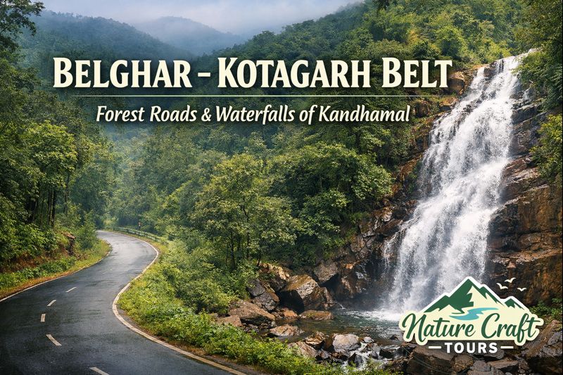
The hook “Forest Roads and Waterfalls” is not a metaphor here; it is the literal geography of the land. Narrow blacktop roads cut through dense sal and teak forests, climbing and descending low hills, while seasonal streams and perennial cascades emerge without warning along the way. For travellers seeking experiential depth rather than checklist sightseeing, the Belghar–Kotagarh belt offers one of the most immersive forest journeys in eastern India.
Destination Overview: Understanding the Belghar–Kotagarh Belt
The Belghar–Kotagarh belt lies in the western and south-western portion of Kandhamal district, a region historically known for its forest cover, tribal communities, and relatively late integration into major transport networks. Belghar functions as a forest-fringed hill town and administrative block headquarters, while Kotagarh sits deeper within the interior, surrounded by reserve forests and river systems that feed the larger Baitarani and Rushikulya basins.
Geographically, the terrain forms part of the Eastern Ghats system, characterised by undulating plateaus, lateritic soil, and dense mixed deciduous forests. Elevations range between 600 and 900 metres above sea level, which gives the region a noticeably cooler and more temperate climate compared to Odisha’s coastal belt. This elevation also contributes to the formation of multiple waterfalls, particularly during and after the monsoon months.
What sets this belt apart is continuity. Unlike isolated hill stations, Belghar and Kotagarh are linked by long forest corridors that remain largely free from urban intrusion. Human settlements are sparse and often clustered around streams, agricultural clearings, and forest edges. This continuity makes the region ideal for slow travel, long drives, and extended nature immersion rather than short sightseeing hops.
Forest Roads: The Defining Travel Experience
The forest roads between Belghar, Kotagarh, Tumudibandh, and adjoining blocks form the backbone of travel in this region. These roads are neither wide highways nor rough trails; they are modest, well-laid routes designed primarily for local movement and forest administration. For travellers, they offer uninterrupted views of woodland landscapes and a constant sense of being enclosed within nature.
Driving or riding through these roads is an experience shaped by subtle details: shafts of sunlight filtering through tall sal trees, sudden openings that reveal distant hill silhouettes, and occasional crossings of small bridges over forest streams. Traffic is minimal, and long stretches may pass without encountering another vehicle. This absence of noise and congestion heightens awareness of the surrounding environment.
Seasonal variations dramatically alter the character of these roads. In summer, dry leaves carpet the forest floor and visibility extends far into the woods. During the monsoon, the same routes turn lush and vibrant, with moss-covered rocks, overflowing culverts, and water flowing beside the asphalt. Post-monsoon months bring clarity, cool air, and the clearest views of waterfalls and valley landscapes.
Waterfalls of the Belghar–Kotagarh Region
Waterfalls are among the most striking natural features of the Belghar–Kotagarh belt. Fed by seasonal rains and perennial forest streams, these cascades are rarely marked by signage or developed viewpoints. Discovering them often involves short walks, local guidance, and an understanding of the terrain.
Pakdajhar and Hill-Stream Cascades
Pakdajhar and several unnamed cascades near Belghar emerge along forest slopes where streams descend sharply from the plateau. These waterfalls are particularly impressive between August and November, when water volume is high but currents are manageable. Unlike crowded tourist waterfalls, these sites remain quiet, allowing visitors to observe natural flow patterns, rock formations, and surrounding vegetation without disturbance.
Seasonal Falls near Kotagarh
The deeper forest zones around Kotagarh host numerous seasonal waterfalls that appear only during and shortly after the monsoon. These falls may not be tall, but their setting—dense forest, birdsong, and mist—creates a sense of remoteness that defines the region. Locals often use these sites for bathing, small rituals, or simple recreation, reflecting an intimate relationship with water sources.
Cultural and Ecological Context
Kandhamal district is home to several indigenous communities, including the Kondh and Kui-speaking populations, whose livelihoods are closely tied to forests and agriculture. In the Belghar–Kotagarh belt, traditional knowledge of forest paths, medicinal plants, and water sources remains actively practiced. Travel through this region therefore intersects with living cultural systems rather than curated heritage displays.
Ecologically, the forests support a range of flora and fauna typical of the Eastern Ghats. Sal dominates higher elevations, while mixed deciduous species occupy lower slopes and valleys. Birdlife is abundant, particularly during early mornings, and while large mammals are elusive, signs of their presence are often visible along forest edges and water sources.
The ecological balance here is delicate. Agriculture is largely rain-fed, and forest resources remain central to daily life. Visitors should approach the region with an awareness that conservation and community well-being are deeply interconnected.
Best Time and Season to Travel
The ideal time to explore the Belghar–Kotagarh belt is between October and February. Post-monsoon months bring full waterfalls, clear skies, and comfortable temperatures for long drives and short treks. Winter mornings can be cool, especially at higher elevations, adding to the hill-region atmosphere.
The monsoon season, from July to September, transforms the landscape into its most dramatic form, with lush greenery and active waterfalls. However, heavy rainfall can affect road conditions and visibility, making travel suitable only for experienced drivers and flexible itineraries.
Summer months are dry and warmer, but still significantly cooler than Odisha’s plains. While waterfalls reduce in volume, forest drives remain pleasant during early mornings and late afternoons.
Ideal Travel Duration and Pace
A meaningful exploration of the Belghar–Kotagarh belt requires a minimum of three to four days. This allows sufficient time to experience forest roads, visit multiple waterfalls, and engage with local landscapes without rushing. Travellers interested in deeper exploration, photography, or extended forest walks may find five to six days more appropriate.
The region rewards slow travel. Long halts, unplanned stops, and conversations with local residents often become the most memorable aspects of the journey.
Route and Accessibility
Belghar is accessible by road from Phulbani, the district headquarters of Kandhamal. Phulbani itself connects to Bhubaneswar and Berhampur via state highways. From Belghar, forest roads extend south-west towards Kotagarh, passing through sparsely populated and scenic terrain.
Public transport options are limited and infrequent. Private vehicles offer the greatest flexibility and allow travellers to stop at unmarked waterfalls and viewpoints. Fuel stations and basic amenities are available in block towns but should not be assumed in forest interiors.
Comparative Landscape Context
Travellers familiar with forest tourism in eastern India may find it useful to view the Belghar–Kotagarh belt within a broader ecological context. Just as a Sundarban Tour introduces visitors to mangrove ecosystems shaped by tides and rivers, Kandhamal’s interior forests reveal a contrasting upland ecology driven by rainfall, elevation, and forest continuity. Both regions demand sensitivity to nature, but their landscapes and rhythms differ fundamentally.
Practical Insights for Responsible Travel
Travellers should carry essentials such as drinking water, basic first aid, and offline navigation tools. Mobile network coverage can be intermittent, particularly between Belghar and Kotagarh. Local guidance is invaluable for identifying safe access points to waterfalls and forest trails.
Respect for local customs and forest regulations is essential. Avoid loud activities, littering, or disturbing water sources. Photography should be undertaken with consent when involving people or village spaces.
Those who have experienced structured nature itineraries, such as a Sundarban Tour Package, will find the Belghar–Kotagarh belt far less formal and far more self-directed. Preparation and adaptability therefore become key components of a successful journey.
The Quiet Strength of Kandhamal’s Forest Heartland
The Belghar–Kotagarh belt does not seek attention. Its value lies in continuity, authenticity, and the understated beauty of forest roads and waterfalls that remain part of everyday life rather than staged attractions. For travellers willing to slow down, listen, and observe, this region offers a rare opportunity to experience Odisha’s upland forests in their most genuine form.
In an era where travel often prioritises speed and spectacle, Belghar and Kotagarh stand as reminders that some landscapes reveal their richness only to those who travel patiently and respectfully. The journey here is not about reaching a single destination, but about moving through a living forest corridor where road, water, and woodland exist in quiet balance.