Bhitarkanika Creek Networks
— Slow Boat Travel Through Mangrove Corridors and Tidal Time
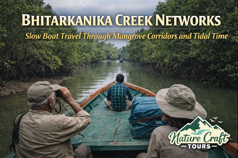
Bhitarkanika is often introduced as a wildlife destination, a mangrove sanctuary known for saltwater crocodiles and estuarine biodiversity. Yet this description, while factually correct, does not capture the lived reality of the region. Bhitarkanika is not experienced through speed or spectacle; it is encountered through creeks, tides, and time. The true geography of Bhitarkanika is its creek network—a labyrinth of narrow tidal channels that demand slow boat movement, patient observation, and an acceptance of nature’s pace.
The hook “Slow Boat + Patience Travel” is not a stylistic preference here; it is an ecological necessity. Engines idle low, boats drift with tidal currents, and the traveller learns to wait—for birds to reveal themselves, for mudbanks to submerge, for the forest to speak in signs rather than announcements. Bhitarkanika rewards those who relinquish urgency and allow the creek network to determine the rhythm of travel.
Destination Overview: Understanding Bhitarkanika’s Creek-Based Geography
Bhitarkanika lies in the deltaic heart of coastal Odisha, within Kendrapara district, where the Brahmani, Baitarani, and Dhamra river systems dissolve into the Bay of Bengal. Unlike linear river landscapes, Bhitarkanika is structured as a web of creeks—interconnected tidal channels bordered by dense mangrove forests and mudflats.
These creeks are not secondary features; they are the primary infrastructure of the region. Villages, forest zones, wildlife habitats, and navigation routes all orient themselves around water movement. The land appears fragmented, but the creeks unify the landscape into a continuous aquatic system.
Bhitarkanika National Park and Wildlife Sanctuary occupy the ecological core of this system, while surrounding areas function as buffer zones where fishing, agriculture, and forest-dependent livelihoods persist. Any meaningful exploration of Bhitarkanika must therefore engage with the creek network itself.
The Creek Network: Anatomy of a Tidal Labyrinth
The creek network of Bhitarkanika consists of primary channels wide enough for motorised boats, secondary creeks that narrow into intimate corridors, and tertiary tidal inlets that appear and disappear with the tide. Navigation depends on tidal timing, water depth, and local knowledge rather than fixed routes.
Mangrove species such as Avicennia, Rhizophora, and Sonneratia line the banks, their root systems stabilising mud while creating complex underwater habitats. These roots shape water flow, influence sediment deposition, and provide shelter for fish, crabs, and juvenile marine life.
For the traveller, movement through this network feels immersive rather than directional. Progress is measured not in distance but in moments—an egret lifting from the bank, a crocodile sliding silently into water, a sudden widening of the creek that opens into a tidal basin.
Slow Boat Travel: The Only Meaningful Way to Move
Speed diminishes Bhitarkanika. Fast movement collapses observation and disrupts wildlife. Slow boat travel, by contrast, aligns with the ecosystem’s logic. Boats move with low engine noise or drift with the current, allowing the forest to reveal itself gradually.
This mode of travel encourages sensory engagement. The smell of salt and decay, the texture of humid air, the subtle change in water colour—all become navigational cues. Silence is not empty here; it is filled with information.
Patience as a Skill
Patience is not passive waiting in Bhitarkanika; it is active attention. Wildlife rarely appears on demand. Instead, it emerges when disturbance recedes. A boat that pauses at a bend may witness a monitor lizard climbing roots or a kingfisher diving repeatedly into still water.
This patience reshapes the traveller’s mindset. The journey becomes less about reaching landmarks and more about inhabiting a moving frame of reference defined by tides and light.
Ecological Significance of the Creek System
Bhitarkanika’s creek networks are among the most productive estuarine ecosystems in India. The mixing of freshwater and seawater creates nutrient-rich conditions that support fish breeding, crustacean populations, and birdlife.
These creeks function as nurseries for marine species that later migrate to open sea. They also act as buffers against cyclones and storm surges, absorbing energy and protecting inland settlements.
The health of the creek system is directly tied to mangrove integrity. Any disruption—whether through pollution, unregulated boating, or embankment alteration—affects the entire deltaic balance.
Wildlife Encounters Through Creek Observation
Bhitarkanika is renowned for its saltwater crocodiles, but an interpretive approach expands attention beyond single-species fascination. Crocodiles are best understood as apex indicators of creek health rather than attractions.
Birdlife is abundant and varied. Herons, storks, egrets, raptors, and migratory species use different creek zones depending on depth, salinity, and vegetation. Early mornings and late afternoons offer the richest observation windows.
Smaller creatures—mudskippers, crabs, insects—reveal micro-ecological processes that sustain larger life forms. Observing these details requires stillness and time, reinforcing the value of patience travel.
Human Presence Along the Creek Edges
Contrary to perceptions of wilderness, Bhitarkanika is a lived landscape. Fishing villages, embankments, and seasonal camps exist along creek margins, particularly in buffer zones.
Local livelihoods are calibrated to tidal cycles. Fishing schedules, crab collection, and boat movement all respond to water levels. These practices represent generations of adaptive knowledge shaped by creek behaviour.
Cultural Memory and Water
Creeks are not merely physical channels; they carry cultural significance. Certain stretches are associated with myths, seasonal rituals, or historical events. Oral narratives often map history onto water routes rather than land boundaries.
For travellers, acknowledging this human-water relationship adds depth to the experience, transforming creeks from scenery into social spaces.
Historical Context: From Maritime Routes to Conservation Zones
Historically, Bhitarkanika’s creeks functioned as inland navigation routes linking coastal ports with interior settlements. Timber, salt, and agricultural produce moved through these channels long before road infrastructure existed.
Colonial forest policies altered access patterns, while post-independence conservation measures formalised protection. The designation of Bhitarkanika as a sanctuary and national park restricted certain activities but preserved the creek network from industrial transformation.
Traces of this layered history remain visible in old embankments, abandoned jetties, and settlement patterns aligned with former navigation routes.
Key Creek Routes and Experiential Highlights
While exact routes vary with season and regulation, certain experiential patterns define Bhitarkanika creek travel.
Primary Creek Corridors
Wider creeks allow extended boat journeys through dense mangrove walls. These routes offer opportunities for observing crocodile basking sites, bird congregations, and tidal flow dynamics.
Secondary and Inner Creeks
Narrower channels create intimate encounters with the forest. Overhanging branches, exposed roots, and shifting shadows heighten sensory awareness. These sections reward slow drifting rather than continuous propulsion.
Tidal Flats and Open Basins
Where creeks open into broader basins, the landscape expands visually. Mudflats emerge at low tide, attracting birds and revealing patterns of sediment movement that shape the delta.
Best Time and Season for Creek-Based Travel
The ideal period for Bhitarkanika creek exploration is between October and March. Post-monsoon months ensure adequate water levels, active wildlife, and manageable weather conditions.
Winter offers cooler temperatures and high bird activity. Summer months are hotter but reveal wildlife congregating near water. The monsoon season, while ecologically significant, limits safe navigation due to strong currents and flooding.
Ideal Travel Duration
Bhitarkanika cannot be meaningfully experienced in haste. A minimum of three days allows basic engagement with creek routes. Four to five days is preferable for travellers seeking deeper observation and varied tidal experiences.
Extended stays allow repetition—returning to the same creek at different times of day or tide to observe change, which is central to understanding the ecosystem.
Route and Accessibility
Bhitarkanika is accessed via Kendrapara district, with approach routes from Bhubaneswar and Cuttack. Road travel leads to designated entry points, from where boat journeys begin.
Movement within the sanctuary is strictly regulated to minimise disturbance. Boats follow approved routes, and timing is coordinated with tides and forest management guidelines.
Comparative Estuarine Perspective
Travellers familiar with other deltaic systems may find instructive parallels. Just as a Sundarban Tourism emphasises tidal rhythms, mangrove navigation, and patient wildlife observation, Bhitarkanika demands a similar surrender to water-led travel. The difference lies in scale and texture, but the principle of patience remains constant.
Practical Insights for Slow Boat and Patience Travel
Travellers should prioritise guides and boat operators who understand tidal behaviour and wildlife ethics. Loud conversation, sudden movements, and unnecessary speed diminish both safety and experience.
Carrying binoculars, sun protection, and hydration is essential. Expectations should be adjusted away from guaranteed sightings toward open-ended observation.
Those accustomed to tightly scheduled itineraries such as a Sundarban Tour Package may initially find Bhitarkanika’s pace challenging. However, the reward lies precisely in this deceleration.
Why Patience Travel Matters in Bhitarkanika
Bhitarkanika’s creek networks operate on ecological time. Rushing through them reduces complexity to surface impressions. Patience travel restores proportion, allowing the traveller to witness relationships rather than isolated events.
In an era where tourism often prioritises speed and volume, Bhitarkanika offers an alternative ethic—one where movement respects the limits of the landscape and understanding arises from waiting rather than seeking.
Letting the Creek Decide the Journey
Bhitarkanika does not reveal itself to those who demand control. Its creeks curve, narrow, widen, and vanish according to tides older than maps. To travel here is to accept guidance from water, light, and silence.
For explorers willing to slow down, to listen, and to wait, the Bhitarkanika creek networks offer more than wildlife encounters. They offer recalibration—a reminder that some landscapes are best understood not by covering ground, but by letting the journey unfold at the pace of the tide.