Harishchandragad + Konkan Kada
— Cliff Drama and Ancient Fort Terrain in the Sahyadri
In the vast mountain spine of the Sahyadri range, where basalt plateaus fracture into sheer escarpments and ancient routes still guide modern footsteps, Harishchandragad stands apart as a landscape of scale, endurance, and memory. Paired with the dramatic precipice of Konkan Kada, this high fort plateau offers one of the most compelling combinations of natural drama and historical terrain in western India. Here, cliffs fall away into the Konkan lowlands, caves shelter millennia-old traces of human presence, and the plateau itself carries the unmistakable weight of time.
Harishchandragad is not merely a trekking destination. It is a layered terrain where geology, weather, history, and myth intersect. The approach routes test resolve, the summit rewards patience rather than speed, and Konkan Kada—an immense concave cliff face—redefines the relationship between land and void. To stand at its edge is to experience scale not as abstraction, but as a physical and emotional reality shaped by wind, cloud, and silence.
Geographical Setting and Plateau Structure
Harishchandragad is located in the Ahmednagar district of Maharashtra, forming part of the northern Sahyadri (Western Ghats) system. The fort rises to an elevation of approximately 1,424 meters above sea level, making it one of the highest fort plateaus in the region. Its summit is not a narrow peak but a broad basalt tableland, fractured by cliffs, caves, and depressions shaped by erosion over millions of years.
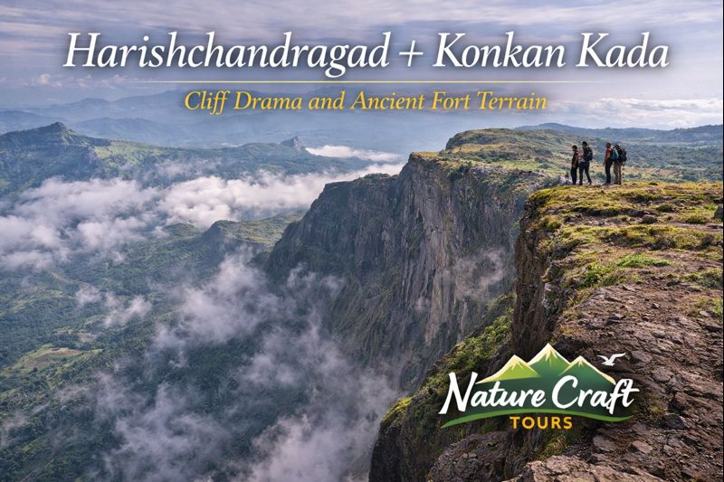
Konkan Kada forms the western edge of this plateau, dropping almost vertically toward the Konkan plains. Unlike sharp ridgelines or angular escarpments, Konkan Kada presents a sweeping concave wall of rock, sculpted by wind and rain. This curvature amplifies sound and airflow, creating unique acoustic and atmospheric effects that define the experience of standing at the cliff edge.
Geological Foundations of Harishchandragad
Basalt Plateaus and Cliff Formation
The fort and its surrounding terrain are composed primarily of Deccan basalt, formed through successive volcanic eruptions millions of years ago. Horizontal lava flows created layered rock strata, later fractured by tectonic stress and eroded by monsoon rainfall. Over time, water exploited joints and weaknesses in the basalt, carving steep edges and creating the dramatic cliffs seen today.
Konkan Kada’s concave shape is a direct result of differential erosion. Softer basalt layers receded faster than harder bands, producing a smooth, inward-curving cliff face rather than a jagged drop. This geological structure contributes to the cliff’s visual drama and its distinctive interaction with wind and sound.
Weather and Rock Interaction
The plateau’s exposed nature makes it highly responsive to weather. During the monsoon, clouds rise from the Konkan plains and spill over the cliff edge, often enveloping the plateau in mist. In winter, temperature fluctuations accentuate rock fracturing, while summer reveals the plateau’s austere basalt character under clear skies.
Harishchandragad as an Ancient Fort Landscape
Harishchandragad’s history predates many well-known Sahyadri forts. Archaeological evidence suggests habitation and ritual activity as early as the 6th century, with later phases of occupation during the medieval period. Unlike forts designed primarily for military dominance, Harishchandragad appears to have functioned as a strategic refuge, religious site, and waypoint along ancient trade and travel routes.
Remnants of fortification walls, water cisterns, and watch points are scattered across the plateau. These structures blend into the rock, emphasizing adaptation to terrain rather than imposition upon it. The fort’s layout reflects an understanding of weather, water storage, and visibility—critical factors for survival at such elevation.
Konkan Kada — The Cliff as Experience
Scale, Wind, and Acoustic Phenomena
Konkan Kada is not simply a viewpoint; it is an environment in itself. The cliff’s concave shape creates powerful updrafts as warm air rises from the Konkan plains below. These currents can be strong enough to support birds—and occasionally sound waves—for remarkable distances.
One of the most discussed phenomena here is the amplification and reflection of sound. Shouts, whistles, or even wind noise can echo back with unexpected clarity, delayed and transformed by the cliff’s curvature. This effect underscores the sheer scale of the formation and reinforces the sense of standing at a geological boundary.
Cloud Movements and Visual Drama
During the monsoon and early post-monsoon months, clouds frequently surge upward along Konkan Kada, spilling over the edge like slow-moving waves. This creates moments where visibility alternates rapidly between vast openness and complete obscurity. The cliff becomes a threshold between worlds—humid lowland and cool plateau.
Key Attractions Across the Plateau
Kedareshwar Cave Temple
One of Harishchandragad’s most significant features is the Kedareshwar cave, which houses a naturally formed Shiva lingam partially submerged in water. Four ancient pillars surround the lingam, one of which is believed to have collapsed, giving rise to local legends associated with cosmic cycles.
The cave’s constant water level, even during dry seasons, points to sophisticated natural filtration and storage within the basalt. Beyond its religious importance, the cave illustrates the intimate connection between geology and ritual practice.
Taramati Peak
Taramati Peak represents the highest point on the plateau and offers expansive views across the Sahyadri range. In clear conditions, distant forts and ridgelines become visible, revealing the interconnected geography of the Western Ghats.
Unlike Konkan Kada’s dramatic verticality, Taramati offers horizontal perspective—a reminder that Harishchandragad is as much about breadth as it is about depth.
Best Time and Season to Visit
Monsoon: Power and Uncertainty
The monsoon season, from June to September, transforms Harishchandragad into a landscape of water, cloud, and movement. Streams appear across the plateau, vegetation flourishes, and Konkan Kada displays its most dramatic cloud activity.
However, monsoon conditions demand caution. Slippery rock surfaces, reduced visibility, and strong winds near the cliff edge can increase risk. Travelers familiar with dynamic water-driven environments—such as those experienced during a Sundarban Trip—will better appreciate the need to adapt plans to weather rather than resist it.
Post-Monsoon and Winter: Stability and Clarity
From October through February, Harishchandragad offers its most balanced conditions. Trails stabilize, skies clear, and night temperatures remain manageable. This period is ideal for extended exploration of the plateau and safe appreciation of Konkan Kada.
Winter mornings often bring crisp air and exceptional visibility, allowing the full scale of the cliff and surrounding ranges to be perceived without obstruction.
Ideal Travel Duration and Trek Rhythm
Harishchandragad is best approached as a two-day experience. This allows time for ascent, plateau exploration, and overnight stay—either in caves or open areas—followed by a second day dedicated to Konkan Kada, Kedareshwar cave, and return.
Rushing the fort diminishes its impact. The plateau’s scale and complexity demand unhurried movement, with time allocated for rest, observation, and adjustment to weather conditions.
Route and Accessibility
Multiple routes lead to Harishchandragad, with the most commonly used approaches starting from Khireshwar, Pachnai, or Nalichi Vaat. Each route varies in difficulty, exposure, and technical demand, offering different perspectives on the mountain.
Road access is available up to the base villages, though final stretches often involve uneven terrain. Public transport options exist but are limited, making private transport the more reliable choice for time-sensitive itineraries.
Ecological Character of the Plateau
Harishchandragad lies within the Western Ghats ecological zone, though its high elevation and exposed plateau create a distinct habitat. Grasslands dominate the summit, interspersed with hardy shrubs and seasonal wildflowers. During the monsoon, amphibians and insects proliferate, while winter brings increased bird activity.
The absence of dense forest on the plateau highlights the role of wind and exposure in shaping vegetation patterns. Life here persists not through abundance, but through resilience.
Cultural Memory and Regional Significance
The fort’s name is associated with the legendary king Harishchandra, a figure symbolizing truth and sacrifice in Indian tradition. While historical attribution remains debated, the persistence of such associations reflects the fort’s long-standing role in regional consciousness.
Nearby villages maintain oral histories connected to the plateau, blending myth, memory, and lived experience. This continuity underscores Harishchandragad’s identity not as an abandoned ruin, but as a landscape still embedded in cultural geography.
Practical Insights for Responsible Exploration
Harishchandragad demands respect for terrain and weather. Proper footwear, layered clothing, and awareness of wind exposure near Konkan Kada are essential. Camping or overnight stays should follow minimal-impact principles, with waste carried out and water sources protected.
Travelers experienced in sensitive environments—such as mangrove ecosystems accessed through a Best Sundarban Tour Package—will recognize similar ethical responsibilities here. The plateau’s openness leaves little margin for careless behavior.
Harishchandragad Beyond Adventure
What distinguishes Harishchandragad and Konkan Kada is not difficulty alone, but depth of experience. The fort invites engagement with time scales that extend beyond individual journeys—geological, historical, and cultural.
Standing at Konkan Kada, one senses not conquest, but perspective. The cliff does not offer dominance over the landscape; it reveals the magnitude of what lies beyond.
Where Stone, Sky, and History Converge
Harishchandragad and Konkan Kada represent the Sahyadri at its most elemental. Stone shaped by fire and water, cliffs shaped by erosion and wind, and human presence shaped by necessity and belief all converge on this plateau.
For those willing to move carefully and observe deeply, this is not merely a trek or a fort visit. It is an encounter with terrain that resists simplification—demanding humility, attention, and time. In return, it offers one of the most profound landscape experiences in the Western Ghats.