Malshej Ghat is not a destination that reveals itself all at once. It is a passage rather than a place, a mountain corridor where road, ridge, cloud, and water interact continuously. Situated along the crest of the Western Ghats, Malshej Ghat transforms most dramatically during the monsoon, when clouds descend to road level, waterfalls erupt from cliff faces, and visibility fluctuates between vast openness and complete enclosure within mist. Unlike hill stations designed for retreat, Malshej functions as a living mountain artery—linking the Konkan and the Deccan, carrying centuries of movement, trade, and seasonal rhythm.
To travel through Malshej Ghat is to experience the Sahyadri not as a static landscape, but as an active system shaped by rainfall, wind, erosion, and human adaptation. Ridge roads trace ancient routes, basalt walls rise abruptly from valleys, and the monsoon reasserts its authority with a force that feels both theatrical and elemental. This is a landscape where weather is not background but protagonist, and where the journey itself becomes the primary experience.
Geographical Setting and Ghat Topography
Malshej Ghat lies on the boundary between Pune and Ahmednagar districts in Maharashtra, forming part of the northern Western Ghats. It acts as a natural gateway between the coastal Konkan belt and the inland Deccan Plateau. The ghat section rises sharply from the western side, climbing through a series of curves, cliffs, and saddles before flattening into high plateau terrain toward the east.
Geologically, the region is composed of layered Deccan basalt, formed through massive volcanic outpourings millions of years ago. Over time, tectonic uplift and intense monsoon erosion fractured these layers, creating steep escarpments and deeply incised valleys. The ghat road follows one such natural weakness, winding along ridgelines and cliff edges that offer both expansive views and sudden drops.
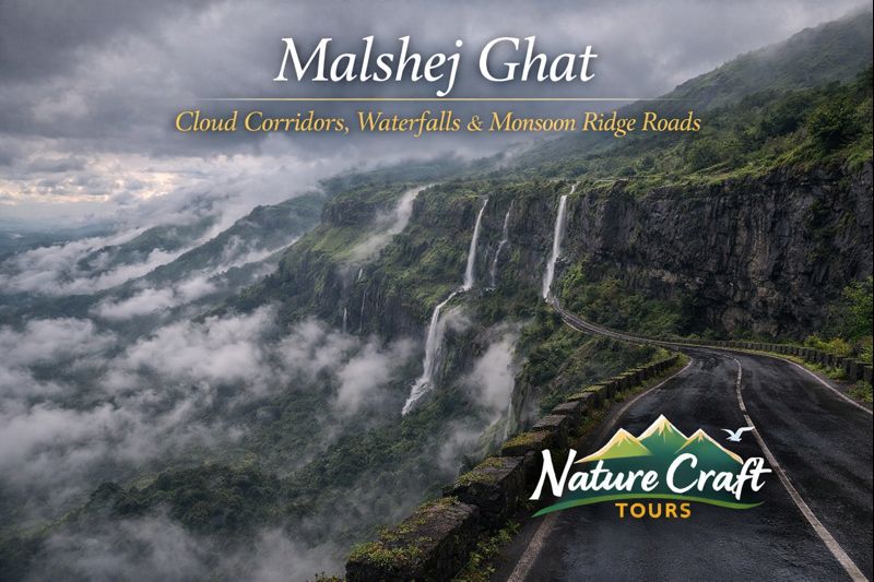
Malshej Ghat as a Cloud Corridor
Monsoon Cloud Dynamics
One of Malshej Ghat’s defining features is its interaction with monsoon cloud systems. Moist air from the Arabian Sea is forced upward as it encounters the Sahyadri escarpment. As it rises, the air cools rapidly, condensing into dense cloud banks that spill across the ridge and into the ghat.
During peak monsoon months, this process occurs almost continuously. Clouds move horizontally across the road, reducing visibility to a few meters before clearing suddenly to reveal distant valleys. These shifting conditions create a sense of motion even when standing still, reinforcing the feeling that the landscape itself is in flux.
Light, Mist, and Perception
Fog and low cloud alter depth perception along the ridge roads. Cliff edges appear and disappear, waterfalls emerge from nowhere, and familiar landmarks are repeatedly reintroduced. This constant recalibration of sight makes travel through Malshej an attentive act, demanding slower speeds and heightened awareness.
Waterfalls and Monsoon Hydrology
Malshej Ghat is renowned for its seasonal waterfalls, which appear along cliff faces, road cuttings, and hidden ravines during the monsoon. Unlike perennial falls fed by large rivers, these are rain-born cascades, responding directly to rainfall intensity and slope gradient.
Water seeps through fractures in the basalt, gathers momentum, and spills outward wherever resistance is weakest. Some waterfalls plunge hundreds of feet into valleys, while others flow directly onto the roadway, temporarily integrating water and infrastructure. These ephemeral features illustrate the immediacy of the monsoon’s influence on the terrain.
Ridge Roads and the Experience of Passage
Engineering and Terrain Adaptation
The road through Malshej Ghat follows contours dictated by geology rather than imposing straight alignments. Curves are frequent, gradients vary sharply, and retaining walls often double as viewing points. This design reflects long-standing adaptation to slope stability, water runoff, and landslide risk.
Driving or riding through the ghat is an immersive experience. The road clings to the mountain, alternately exposing travelers to vast drop-offs and enclosing them within rock faces and vegetation. During the monsoon, the road becomes a moving observation platform for cloud movement and water flow.
Historic Routes and Connectivity
Malshej Ghat has long served as a transit route between coastal and inland regions. Before modern roads, it was traversed by traders, pilgrims, and pastoral communities moving with seasonal cycles. The current alignment follows these older pathways, preserving the ghat’s role as a corridor rather than a destination in isolation.
Best Time and Season to Visit
Monsoon: The Defining Season
The monsoon, from late June to September, is when Malshej Ghat reveals its most distinctive character. Waterfalls are active, vegetation is at its lushest, and cloud cover creates constantly changing visual conditions. This season defines the ghat’s reputation and draws travelers seeking atmospheric rather than recreational experiences.
However, monsoon travel requires caution. Reduced visibility, slippery surfaces, and occasional rockfall demand disciplined driving and flexible planning. Travelers experienced in weather-driven landscapes—such as tidal forests and river deltas encountered during a Sundarban Trip—will recognize the importance of adjusting expectations to environmental conditions.
Post-Monsoon and Winter: Clarity and Structure
From October through February, Malshej Ghat transitions into a clearer, more stable landscape. Waterfalls diminish, skies open, and long-distance views across valleys become more consistent. This period highlights the structural beauty of the terrain—cliff lines, ridges, and plateau edges stand out sharply against the sky.
Winter mornings can be cool, but daytime temperatures remain comfortable, making this season suitable for slow drives, photography, and short walks near viewpoints.
Ideal Travel Duration and Journey Planning
Malshej Ghat can be experienced as a half-day drive, but a more rewarding approach involves allocating one to two days. This allows time for multiple passes through the ghat under different light and weather conditions, as well as exploration of surrounding plateaus, lakes, and viewpoints.
Staying longer enables travelers to observe the subtle daily cycles of cloud formation, waterfall activity, and traffic flow—elements that collectively define the ghat’s rhythm.
Route and Accessibility
Malshej Ghat is accessible by road from both Mumbai and Pune, with the approach typically passing through Junnar or Alephata. The ghat road itself is well-maintained but demands careful driving, particularly during the monsoon.
Public transport connects nearby towns, but flexibility is limited. Private vehicles allow greater control over timing, especially when weather conditions change rapidly.
Key Attractions and Natural Highlights
Ghat Viewpoints and Cliff Edges
Numerous informal viewpoints line the ghat road, offering perspectives over deep valleys and distant plains. These are not formal observation decks but natural pauses along the route, where travelers can safely stop to absorb the scale of the landscape.
Seasonal Waterfall Zones
Certain stretches of the road become focal points during heavy rainfall, with multiple waterfalls visible simultaneously. These zones shift year to year, depending on rainfall patterns and minor geological changes.
Surrounding Plateau Lakes and Grasslands
Beyond the ghat itself, the high plateaus east of Malshej host seasonal lakes and open grasslands. These areas provide contrast to the enclosed, vertical experience of the ghat, offering horizontal space and quieter atmospheres.
Ecological Characteristics
Malshej Ghat lies within the Western Ghats biodiversity region, though its ecology reflects transitional conditions between coastal forest and inland plateau. During the monsoon, the area supports a burst of life—amphibians, insects, and migratory birds become prominent.
Vegetation includes montane grasses, shrubs, and patches of forest in sheltered valleys. The ephemeral nature of water sources shapes species behavior, reinforcing the region’s dependence on seasonal cycles.
Cultural and Historical Context
The ghat has long featured in regional movement and memory. Nearby forts, caves, and settlements indicate centuries of strategic use, trade passage, and seasonal migration. While Malshej itself is not dominated by monumental structures, its significance lies in continuity of use rather than singular historical events.
Local communities maintain strong ties to the land, adapting agriculture and grazing to monsoon patterns. This relationship underscores the ghat’s identity as a working landscape rather than a preserved enclave.
Practical Insights for Thoughtful Travelers
Traveling through Malshej Ghat requires respect for weather and terrain. During the monsoon, headlights, moderate speeds, and frequent pauses are essential. Walking near cliff edges should be approached with caution, particularly in fog or high wind.
Facilities along the ghat are limited, reinforcing the importance of self-sufficiency and waste responsibility. Travelers accustomed to sensitive environments—such as mangrove reserves visited through a Best Sundarban Tour Package—will recognize similar ethical obligations here.
Malshej Ghat Beyond Scenic Travel
What distinguishes Malshej Ghat is not a single viewpoint or landmark, but the continuity of experience it offers. The ghat is never static; it changes with every kilometer, every cloud movement, every hour of rain or sun.
For researchers, photographers, and reflective travelers, Malshej provides a rare opportunity to observe the Sahyadri as an active system—where geology, hydrology, and atmosphere interact visibly and continuously.
A Living Monsoon Passage
Malshej Ghat stands as one of the Western Ghats’ most evocative corridors, where cloud, water, and stone shape travel into experience. It does not offer escape from nature, but immersion within it—sometimes serene, sometimes demanding, always instructive.
For those willing to slow down and observe, the ghat reveals itself as more than a scenic route. It becomes a lesson in seasonal rhythm, landscape resilience, and the enduring dialogue between mountain and monsoon.