Nathu La Pass (Permit-Dependent)
— Where History, Altitude, and Diplomacy Meet the Himalaya
A Pass Defined by More Than Height
High in the eastern Himalaya, where oxygen thins and the landscape sheds all excess, Nathu La Pass emerges not merely as a mountain crossing but as a defining line between geography and geopolitics. Located at an elevation of approximately 4,310 metres (14,140 feet), Nathu La is one of the highest motorable passes in the world and one of the most symbolically charged corridors in modern South Asian history. Its name, derived from Tibetan words meaning “listening ears pass,” feels remarkably appropriate for a place that has long stood witness to trade, conflict, negotiation, and guarded coexistence.
For travellers, Nathu La Pass is never an accidental stop. It is a destination governed by permits, weather, altitude, and national interest. Unlike casual hill viewpoints, reaching this pass demands preparation, patience, and respect for the land’s physical and political realities. This article approaches Nathu La not as a thrill-seeking excursion, but as a layered landscape—one shaped by ancient trade routes, colonial legacies, military vigilance, and the sheer force of Himalayan geology.
Destination Overview: Geography at the Edge of Nations
Location and Spatial Context
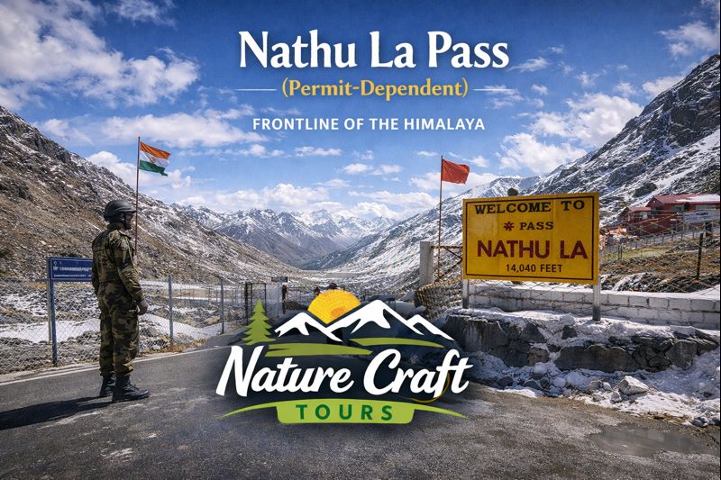
Nathu La Pass lies in East Sikkim, forming part of the border between India and the Tibetan Autonomous Region of China. It is situated roughly 56 kilometres east of Gangtok and is accessed via a high-altitude road that ascends steadily through alpine terrain. The pass connects Sikkim with the Chumbi Valley of Tibet, making it a historically vital corridor between the Indian subcontinent and the Tibetan plateau.
The surrounding landscape is stark and expansive. Vegetation thins dramatically as altitude increases, giving way to exposed rock faces, glacial debris, and vast open slopes. The absence of visual clutter heightens the sense of scale, making human presence—whether civilian or military—feel provisional against the immensity of the terrain.
Altitude, Climate, and Environmental Extremes
At over 4,300 metres, Nathu La exists in a severe alpine climate. Temperatures remain low throughout the year, and weather conditions can change with little warning. Even during summer, strong winds and sudden cloud cover are common, while winter brings heavy snowfall that often renders the pass inaccessible.
The thin atmosphere significantly affects physical exertion. Shortness of breath, cold-induced fatigue, and reduced stamina are natural responses, underscoring the importance of acclimatisation and measured movement.
Historical Significance: From Caravan Route to Controlled Crossing
Ancient Trade and the Silk Route Legacy
For centuries, Nathu La formed part of a trans-Himalayan trade network linking Bengal and Sikkim with Tibet. Caravans carrying silk, wool, salt, and precious stones moved through this pass, making it a vital artery of economic and cultural exchange. The route contributed to the diffusion of Buddhism, art, and linguistic influences across the region.
These historical movements are not visible today in physical form, yet the pass’s alignment and terrain still reflect its original function as a natural gateway through otherwise formidable mountains.
Colonial Era and Strategic Reconfiguration
During the British colonial period, Nathu La gained strategic prominence as the British sought to secure Himalayan frontiers and regulate access to Tibet. Roads and administrative controls gradually replaced informal trade arrangements, reshaping the pass’s role from commercial artery to geopolitical asset.
The mid-20th century further altered its status, as changing national boundaries and conflicts transformed Nathu La into a fortified and closely monitored zone.
Modern History and Reopening
Following decades of closure after the 1962 Sino-Indian conflict, Nathu La was reopened in 2006 for limited border trade and controlled civilian access. This reopening marked a significant diplomatic gesture, symbolising cautious engagement rather than unrestricted openness.
Today, the pass functions under strict regulations, balancing strategic necessity with symbolic connectivity.
Cultural and Political Dimensions
Border Rituals and Symbolism
At the pass, cultural expression takes on a restrained, almost ceremonial form. National flags, boundary markers, and guarded enclosures replace temples or monuments. These symbols convey sovereignty and vigilance rather than celebration, reminding visitors that they stand at a geopolitical threshold.
The experience is often solemn rather than festive, shaped by the awareness of historical tensions and present-day responsibilities.
Local Perception and Regional Identity
For residents of Sikkim, Nathu La represents both pride and caution. It is a reminder of the state’s strategic importance and its unique position at the intersection of South and Central Asian histories. The controlled nature of access reinforces the idea that this landscape is not merely scenic but consequential.
Ecological Context: Life at the Edge of Viability
Alpine Ecosystems
The ecological environment around Nathu La is sparse but resilient. Vegetation is limited to hardy alpine grasses, mosses, and occasional dwarf shrubs that survive brief summers and long, harsh winters. During warmer months, small patches of colour emerge as alpine flowers bloom rapidly within a narrow seasonal window.
Animal life is equally specialised. Species adapted to cold and altitude, such as yaks and high-altitude birds, dominate the ecological niche. Human activity, though regulated, poses ongoing challenges to this fragile system.
Environmental Sensitivity and Regulation
The strict permit system and military oversight have unintentionally served as conservation mechanisms, limiting mass tourism and associated environmental degradation. Soil erosion, waste management, and habitat disturbance remain concerns, but controlled access has helped mitigate large-scale impact.
Route and Accessibility
Approach from Gangtok
The journey to Nathu La begins in Gangtok, following a mountain road that ascends steadily through East Sikkim. The route passes through Tsomgo (Changu) Lake and other high-altitude points, offering natural pauses for acclimatisation. Road conditions are generally good during open seasons, though weather can cause sudden delays.
Travel time typically ranges between three and four hours one way, depending on traffic, checkpoints, and weather conditions.
Permit-Dependent Access
Civilian access to Nathu La is strictly permit-based and limited to Indian nationals. Permits are issued through authorised channels in Gangtok and are subject to daily quotas, weather conditions, and security considerations. Identification checks are mandatory at multiple points along the route.
Best Time and Season to Visit
Late Spring to Early Summer (May to June)
This period offers the most reliable access, with relatively stable weather and cleared roads. Snow may still line the pass, enhancing visual contrast without severely restricting movement.
Autumn (September to October)
Post-monsoon months bring clear skies and crisp air, making visibility exceptional. Temperatures drop quickly, but the reduced tourist flow allows for a more contemplative experience.
Winter and Monsoon Constraints
During winter, heavy snowfall frequently closes the pass. Monsoon months introduce landslide risks and persistent cloud cover, making access unpredictable.
Ideal Travel Duration and Itinerary Planning
A visit to Nathu La is generally structured as a full-day excursion from Gangtok, often combined with Tsomgo Lake and nearby high-altitude points. Due to altitude constraints, prolonged stays at the pass itself are neither permitted nor advisable.
Travellers who enjoy contrasting landscapes often integrate such high-altitude experiences with lowland ecosystems elsewhere in India. For instance, pairing Sikkim’s alpine frontier with riverine wilderness explored through a Sundarban Tour provides a striking illustration of the country’s ecological diversity.
Key Attractions and Highlights
The Border Zone Experience
Standing at Nathu La offers a rare opportunity to observe an active international border at close range. Fencing, signboards, and guarded enclosures convey a sense of immediacy rarely found in other travel contexts.
Panoramic Himalayan Vistas
On clear days, the surrounding mountains unfold in layered profiles, extending deep into the Tibetan plateau. These views reinforce the pass’s role as both gateway and barrier.
Practical Insights for Travellers
Health and Acclimatisation
Visitors should avoid rushing the ascent, stay hydrated, and remain alert to signs of altitude discomfort. Minimal physical exertion at the pass is strongly advised.
Clothing and Preparation
Insulated layers, windproof outerwear, gloves, and sun protection are essential even during summer months. Weather can shift rapidly, and preparedness is critical.
Conduct and Compliance
Photography restrictions, movement boundaries, and behavioural guidelines must be strictly followed. The area’s sensitivity demands respect and cooperation.
Nathu La in a Broader Travel Perspective
Nathu La Pass occupies a unique position in Indian travel narratives. It is neither purely scenic nor purely historical, but a living space shaped by diplomacy, defence, and terrain. Travellers seeking a holistic understanding of India’s geographic range often balance such frontier experiences with other regions, including deltaic landscapes accessed through itineraries like a Sundarban Tour Package.
A Pass That Demands Perspective
Nathu La Pass is not defined by ease or indulgence. It is a place where the Himalaya asserts its authority and human systems adapt cautiously around it. For the thoughtful traveller, the pass offers more than altitude—it offers context. It reminds us that landscapes can be both beautiful and consequential, and that access itself can be a privilege shaped by history.
In standing at Nathu La, one stands not just at the edge of a nation, but at the intersection of past exchange, present vigilance, and uncertain futures. It is a journey that lingers long after the descent.