Rohtang Region:
The High-Altitude Snow Corridor of the Western Himalaya (Seasonal Access)
Beyond the green valleys and settled rhythms of Manali rises a dramatically different Himalayan world—one defined not by permanence, but by season. The Rohtang region is not a destination that exists year-round in the conventional sense. It is a high-altitude snow corridor, alternately sealed and revealed by climate, where access itself becomes part of the experience. Roads vanish under snow for months, landscapes lie dormant, and then—briefly and powerfully—the corridor opens, allowing passage across one of the most striking transitional zones in the Western Himalaya.
Rohtang is not simply a mountain pass or a sightseeing stop. It is a threshold: between valleys and plateaus, between temperate forest and cold desert, between predictable travel and weather-dependent uncertainty. To approach Rohtang with seriousness is to recognize that this region is governed less by human schedules and more by snowpack, melt cycles, and altitude. Every journey here is conditional, every view earned.
This article explores the Rohtang region as a seasonal high-altitude landscape—examining its geography, climate logic, cultural role, and practical realities. It is written from an explorer’s perspective, prioritizing understanding over spectacle and preparation over haste.
Destination Overview: Understanding the Rohtang Region
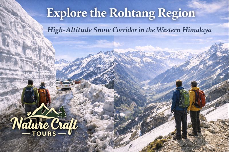
The Rohtang region centers around Rohtang Pass, situated at approximately 3,978 meters above sea level. This elevation places it well above the tree line and firmly within the high-alpine environment. The pass forms a natural gateway between the Kullu Valley on the southern side and the Lahaul–Spiti plateau to the north.
Geographically, Rohtang sits within a zone shaped by glaciation and extreme weather. Valleys narrow, slopes steepen, and vegetation thins rapidly as altitude increases. The region is exposed to strong winds, sudden fog, and rapid temperature shifts. These factors make Rohtang less a “place to stay” and more a corridor to be crossed during a limited seasonal window.
Unlike permanent settlements, the Rohtang region functions episodically. For much of the year, it is inaccessible. When it opens, movement intensifies, then fades again as snow returns. This cyclical nature defines both its character and its challenges.
A Corridor Rather Than a Destination
Rohtang is best understood not as a single viewpoint or attraction, but as a moving landscape—experienced along the road itself. Snow walls, meltwater streams, exposed rock faces, and distant glaciers appear sequentially, creating a narrative of ascent and transition.
Geography and Altitude: Where Valleys Give Way to Plateaus
The ascent toward Rohtang marks a dramatic shift in Himalayan geography. Starting from the forested slopes above Manali, the road climbs steadily through deodar and pine zones before entering sparse alpine terrain. Beyond a certain point, vegetation disappears almost entirely, replaced by rock, ice, and seasonal snowfields.
The Southern Approach: From Forest to Snowline
The southern approach from Manali is a study in vertical ecological transition. Lower elevations support forests and meadows. As altitude increases, trees become stunted and eventually vanish. This transition is visible within a short driving distance, making Rohtang one of the most accessible examples of altitudinal zoning in the Himalaya.
The Northern Drop: Toward the Cold Desert
On the northern side, the landscape opens into the Lahaul region, characterized by broader valleys, minimal vegetation, and arid conditions. This stark contrast—lush south, dry north—underscores Rohtang’s role as a climatic and ecological divide.
Seasonal Access: Snow as the Gatekeeper
Access to the Rohtang region is governed entirely by snow. Unlike lower mountain roads that remain open with maintenance, Rohtang is sealed by natural accumulation for several months each year.
Winter Closure and Dormancy
From late autumn through early spring, heavy snowfall renders the pass impassable. During this period, the region lies dormant. Roads disappear, and the landscape resets under deep snow cover. This dormancy is essential to the region’s ecological balance.
The Opening Window
Typically, access resumes in late spring or early summer, depending on snowfall levels and clearing operations. Even then, opening is gradual and conditional. Early season travel often involves navigating towering snow walls and meltwater runoff.
Why Seasonal Access Matters
Seasonal closure limits overuse and preserves fragile alpine systems. It also reinforces the idea that Rohtang cannot be treated as a casual destination. Timing is not a preference here—it is a requirement.
Cultural and Historical Significance of the Rohtang Corridor
For centuries, Rohtang has served as a vital passage rather than a settlement. Traders, shepherds, and travelers relied on this corridor to move between regions with vastly different climates and resources.
Trade and Movement
Historically, Rohtang enabled seasonal trade between Kullu and Lahaul. Goods, livestock, and cultural practices moved across this high pass during narrow seasonal windows. This movement shaped social ties across regions that might otherwise have remained isolated.
Pastoral and Survival Knowledge
Local communities developed deep knowledge of weather patterns, snow behavior, and safe passage timings. This traditional understanding remains relevant, even as modern vehicles replace foot travel.
Ecological Sensitivity of the High-Altitude Zone
The Rohtang region lies within one of the most fragile ecological zones of the Himalaya. Alpine systems recover slowly from disturbance, and even small impacts can have long-term consequences.
Alpine Vegetation and Recovery
During the brief summer, alpine grasses and flowers emerge rapidly, completing life cycles in a matter of weeks. Trampling, waste, or soil compaction can disrupt this delicate process.
Glacial and Meltwater Systems
Snowfields and small glaciers feed meltwater streams that contribute to the larger Beas basin. Disruption here affects water availability far downstream.
Best Time and Season to Travel
Late Spring to Early Summer
This is the classic window for Rohtang access. Snow walls remain high, offering dramatic visuals, while roads are newly cleared. Weather can be unpredictable, requiring flexibility.
Mid-Summer
Conditions stabilize, snow recedes slightly, and access becomes more reliable. This period offers clearer views but less dramatic snow accumulation.
Early Autumn
Before winter closure begins, autumn offers crisp air and reduced traffic. Snow may reappear suddenly, signaling the end of the travel season.
Ideal Travel Duration for the Rohtang Region
Rohtang itself is not a multi-day destination, but understanding it requires more than a rushed visit. A dedicated day, integrated into a longer Himalayan itinerary, is ideal.
Suggested Time Allocation
- Early departure from Manali to allow weather margin
- Several hours along the corridor for observation and acclimatization
- Flexible return timing based on conditions
Route and Accessibility
The primary approach to Rohtang is via the Manali–Rohtang road. This route climbs steadily, with increasing exposure and decreasing services as altitude rises.
Road Conditions and Permits
Access is regulated during peak seasons to manage traffic and environmental pressure. Travelers must account for variable road conditions and possible delays.
Movement at Altitude
Walking short distances at Rohtang can feel strenuous due to altitude. Slow movement and frequent pauses are advisable.
Key Highlights and Observational Points
Snow Walls and Melt Channels
Early in the season, towering snow walls define the corridor. Meltwater channels cut across roads and slopes, illustrating the power of seasonal thaw.
Panoramic Transitions
Clear days reveal distant peaks and the stark contrast between southern greenery and northern aridity.
Wind and Light at High Altitude
Wind patterns and rapidly shifting light create an ever-changing atmosphere. These sensory elements are central to the Rohtang experience.
Rohtang in a Broader Landscape Perspective
Rohtang represents one extreme of seasonal access in India. Elsewhere, landscapes are shaped by opposite forces—tides, floods, and mangrove growth rather than snow and ice.
Travelers who contrast high-altitude corridors like Rohtang with water-dominated regions explored on a Sundarban Trip gain deeper insight into how climate dictates movement, access, and cultural adaptation.
Practical Insights for Travelers
Clothing and Gear
Layered clothing is essential, even in summer. Windproof outer layers, gloves, and sun protection are necessary due to exposure.
Health and Acclimatization
Altitude effects can be significant. Hydration, slow movement, and awareness of symptoms are critical.
Environmental Responsibility
Carry back all waste. Avoid walking on exposed vegetation. Respect restricted zones and seasonal regulations.
Integrating Rohtang into Wider Travel Plans
Rohtang is best experienced as part of a larger journey that balances extreme and moderate environments. Combining high-altitude travel with low-lying ecosystems—such as those included in a Best Sundarban Tour Package—offers a fuller understanding of India’s geographic diversity.
A Thoughtful One-Day Plan for Rohtang Access
Early Start and Gradual Ascent
Depart before peak traffic. Allow time for observation at multiple elevations.
High-Point Observation
Spend limited but focused time near the pass, prioritizing acclimatization and awareness over activity.
Timely Descent
Begin descent before afternoon weather shifts. Conditions can change rapidly.
Rohtang as a Lesson in Seasonal Geography
The Rohtang region is not defined by permanence, comfort, or convenience. It is defined by timing, restraint, and respect for natural limits. Snow governs access, altitude governs pace, and geography governs possibility.
For travelers willing to accept these conditions, Rohtang offers more than views—it offers understanding. It reveals how the Himalaya controls movement and how humans, for generations, have learned to move only when the mountains allow it.