Zuluk – Gnathang – Kupup Circuit (Old Silk Route):
High-Altitude Passage Through History, Landscape, and Memory
The Zuluk–Gnathang–Kupup circuit is not merely a scenic high-altitude drive in East Sikkim; it is a journey across layers of geography and time. This route follows a segment of the ancient Old Silk Route, a transcontinental trade network that once connected the Tibetan plateau with the plains of Bengal. Today, the circuit stands as one of the most evocative cultural landscapes in the Eastern Himalaya—where dramatic mountain engineering, fragile alpine ecology, and human endurance converge.
Unlike mainstream Himalayan destinations shaped primarily by tourism, this circuit retains an austere, almost elemental character. Weather, terrain, and altitude dictate the pace of travel, while the silence of high plateaus and the sudden appearance of military outposts remind visitors that this is both a historic corridor and a strategically sensitive frontier. For travellers seeking depth rather than comfort, the Zuluk–Gnathang–Kupup circuit offers a rare opportunity to experience the Himalaya as a lived passage rather than a postcard image.
Destination Overview: Understanding the Old Silk Route Circuit
Geographical Scope and Altitudinal Range
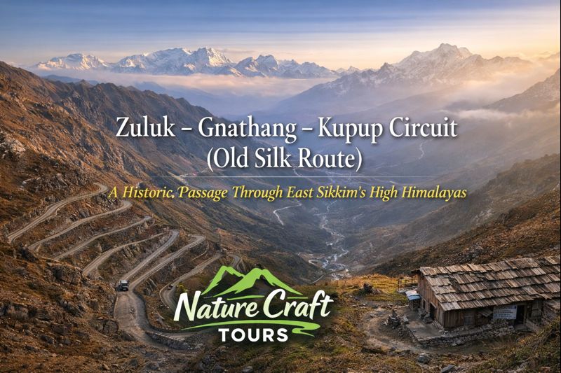
The Zuluk–Gnathang–Kupup circuit lies in East Sikkim, extending from mid-altitude forested slopes to stark, wind-swept plateaus close to the Indo–Tibetan border. Altitudes rise rapidly along this route, ranging from approximately 2,800 metres at Zuluk to over 4,000 metres near Kupup Lake. This sharp elevation gain shapes not only the landscape but also travel logistics, climate, and human settlement.
The circuit traverses ridges, mountain passes, glacial basins, and high meadows, creating a striking sequence of ecological zones. Dense forests gradually give way to alpine grasslands, barren rock faces, and vast open skies. Each segment of the route reveals a different expression of the Eastern Himalaya.
Why This Circuit Is Unique
What distinguishes this circuit from other Himalayan drives is its historical continuity. The road follows alignments that were once foot and mule tracks used by traders transporting silk, salt, wool, and precious stones. Unlike modern highways built purely for efficiency, this route retains the logic of older mountain movement—zigzag ascents, ridge-hugging paths, and strategic viewpoints.
Today, civilian travel is permitted under regulated conditions, allowing visitors to engage with a landscape that remains both historically resonant and geopolitically significant.
Historical Context: The Old Silk Route in the Eastern Himalaya
Trade, Transit, and Cultural Exchange
The Old Silk Route was not a single road but a network of interlinked pathways stretching from China through Central Asia, Tibet, and into the Indian subcontinent. The segment passing through present-day East Sikkim connected Tibetan trading centres with the markets of Kalimpong and the plains beyond.
Caravans moved slowly across these mountains, stopping at seasonal settlements that later evolved into villages such as Zuluk and Gnathang. Along with goods, these routes facilitated cultural exchange—introducing architectural styles, religious ideas, and social practices that shaped Himalayan societies.
From Trade Corridor to Strategic Frontier
With changing political boundaries in the twentieth century, the commercial function of the route declined, but its strategic importance increased. Today, the circuit runs close to sensitive border areas, and military presence is an integral part of the landscape. This transition from trade to defence adds another layer of meaning to the journey, highlighting how geography continually reshapes human priorities.
Zuluk: The Gateway Village of the Eastern Himalaya
Landscape and Settlement Pattern
Zuluk is often the first major stop on the circuit, perched dramatically on a steep hillside. The village is known for its winding road, which forms a series of sharp hairpin bends ascending the mountain face. This road itself has become emblematic of the region’s engineering ingenuity.
Houses in Zuluk are compact and functional, adapted to cold winters and limited space. The settlement reflects a balance between human habitation and a challenging environment, where agriculture is limited and livelihoods depend largely on seasonal activity.
Experiential Significance
Zuluk serves as a transitional zone—both geographically and psychologically. It marks the shift from forested mid-altitudes to the stark openness of the high plateau. For travellers, it is also an important acclimatisation point before ascending further.
Gnathang (Nathang): High Plateau of Winds and Memory
The Character of a High-Altitude Settlement
Gnathang lies on a broad, open plateau where the scale of the landscape changes dramatically. Here, the horizon stretches wide, and the sense of exposure becomes palpable. The village consists of a small cluster of structures, many of which serve seasonal or military-related functions.
Weather in Gnathang is unpredictable, with sudden temperature drops and strong winds even during relatively stable seasons. This harshness underscores the resilience required to inhabit or traverse such environments.
Historical Role and Present Reality
Historically, Gnathang functioned as a rest point for caravans crossing the plateau. Today, its significance lies in its strategic location and its role as a reminder of the human capacity to adapt to extreme conditions.
Kupup and the High Lakes
Kupup Lake and Surrounding Features
Kupup is best known for its high-altitude lake, often referred to locally as an elephant-shaped water body when viewed from certain angles. Set against barren hills and open sky, the lake presents a stark yet compelling visual composition.
Nearby features include mountain passes, memorials, and military installations that collectively illustrate the layered significance of the region.
Environmental Fragility
The Kupup region is ecologically sensitive. Vegetation is sparse, and recovery from disturbance is slow. Travellers should approach this landscape with heightened awareness of their impact, recognising that even minor disruptions can have long-term effects.
Best Time and Season to Travel
Spring (April to May)
Spring offers relatively stable weather, melting snow, and clearer access to higher sections of the circuit. This season balances visibility with manageable temperatures.
Summer and Monsoon (June to September)
While lower sections receive heavy rainfall, higher plateaus may experience rapid weather shifts. Travel during this period requires flexibility and preparedness for delays.
Autumn (October to November)
Autumn is often considered the most favourable season. Skies are clear, temperatures are cold but tolerable, and visibility across the plateau is at its best.
Winter (December to March)
Winter travel is highly restricted due to snow and extreme cold. Only experienced travellers with appropriate permissions should consider this period.
Ideal Travel Duration and Itinerary Structure
A minimum of three to four days is recommended to complete the Zuluk–Gnathang–Kupup circuit comfortably. This allows time for acclimatisation, weather-related delays, and unhurried exploration.
Travellers who have explored contrasting ecosystems—such as the tidal forests and waterways encountered on a Sundarban Tour—often find this circuit illuminating in its stark difference, demonstrating the extraordinary ecological range contained within the Indian subcontinent.
Route and Accessibility
Approach Routes
The circuit is accessed via East Sikkim, with roads gradually ascending from lower elevations. Permits are mandatory, reflecting the area’s sensitive status. Travel is best undertaken during daylight hours, with careful attention to road conditions.
Road Conditions and Travel Considerations
Road quality varies significantly along the route, from paved sections to rough mountain tracks. Weather can alter conditions rapidly, making contingency planning essential.
Cultural and Ecological Significance
The Zuluk–Gnathang–Kupup circuit stands as a cultural landscape shaped by movement—of traders, soldiers, and travellers across centuries. Ecologically, it represents a fragile alpine system where human presence must remain carefully managed.
Understanding this balance enhances the travel experience, transforming the circuit from a scenic drive into a lesson in historical geography.
Practical Insights for Responsible Travellers
Acclimatisation, hydration, and respect for regulations are critical. Photography should avoid sensitive areas, and waste management is a personal responsibility in regions with limited infrastructure.
Travellers who apply the same ethical awareness practiced in other sensitive landscapes—such as those visited through a Sundarban Tour Package—will find the journey more meaningful and sustainable.
A Corridor Beyond Scenery
The Zuluk–Gnathang–Kupup circuit is not defined by comfort or convenience. Its value lies in its authenticity as a mountain corridor shaped by history, necessity, and endurance. For those willing to travel thoughtfully, it offers an encounter with the Himalaya that is both demanding and deeply rewarding.
Here, roads are not merely routes between destinations—they are narratives etched into rock and sky, carrying the memory of journeys far older than modern travel itself.